This post by Graham Dabbs (Igoda Farm) and Bruce Clegg (The Malilangwe Trust) describes a pilot program of soil erosion and flood control on unprotected farmland adjacent to an important wildlife conservancy in the lowveld of Zimbabwe. The conservation work, using the Vetiver System, benefits: (a) the poor, low income, Chitsa farming community, through higher and more secure farm incomes (drought proofing, soil fertility improvement); (b) the adjacent wildlife conservancy by stopping the pre-project sediment flows/flooding from the farmland that was destroying critical grazing areas in the conservancy that are key to the survival of the white rhino and Lichtenstein’s hartebeest; and (c) the owner operator of commercial farm that supplied the vetiver plant material and technical “know how” in vetiver’s application design and management. Thus far the pilot project has proved an excellent and acceptable demonstration, and the complete project will be completed by end 2022. This type of partnership between beneficiary (in this case farmers), the private sector (plant supply and technology transfer), and NGO (the conservancy – the funder) is a very effective and important way to accelerate the adoption of the Vetiver System, and should be used as a model, with of course modifications, in many other areas. Here follows the details of the project.
Stabilization of Soil Erosion in the Agricultural Fields of the Chitsa Communal Lands in Zimbabwe Using Vetiver Grass (Chrysopogon zizanioides).
Graham Dabbsa,* & Bruce Cleggb
aIgoda Farm, Chiredzi, Zimbabwe bThe Malilangwe Trust, Chiredzi, Zimbabwe *Corresponding author: Tel. +263 77 260 1305; email [email protected]
Introduction
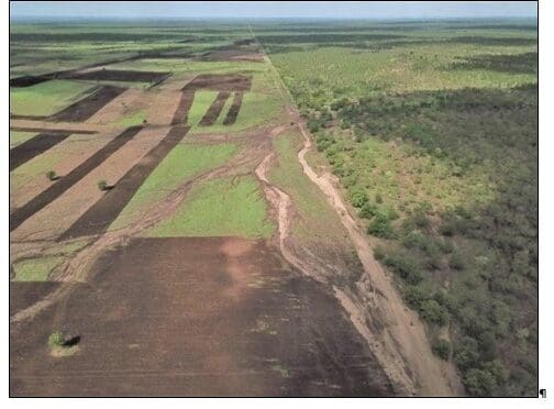
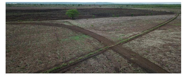
The Chitsa Communal Land is situated in the semi-arid, south-eastern lowveld of Zimbabwe. People living in the area practice rain fed cultivation of sorghum and maize but because of the area’s low average annual rainfall (≈450 mm) and frequent droughts, adequate yields are only realised in four out of every ten years. The inhabitants are poor, and live from hand-to-mouth, with little means to improve their lives. In recent decades, the demand for agricultural land in Chitsa has resulted in the clearing of large tracts of natural woodland. In many instances, clearing has been carried out with little regard for the protection of existing drainage lines, and this has led to uncontrolled runoff and the development of extensive networks of eroding rills and gullies (Figure 1). If left
unchecked, soil erosion is predicted to render many of the fields useless within the next 15 years. This will be a tragedy of large proportions because thousands of people living in the area rely on cropping for their survival.
In Chitsa, the negative effects of soil erosion on agriculture are obvious and widely apparent, but downstream impacts in adjacent Gonarezhou National Park and Malilangwe Wildlife Reserve are also significant. After heavy rain, large volumes of runoff exit the Chitsa fields and flood parts of Gonarezhou and Malilangwe. The flood waters are highly erosive because of their large volume and velocity, and the damage downstream is often more severe than in the fields. Dambo grasslands that were an important source of grass forage for species such as white rhinoceros and Lichtenstein’s hartebeest (both endangered in Zimbabwe) have already been lost. In addition, the thousands of tonnes of sediment is dumped annually into the Gulugi, Chiloveka and Runde Rivers having a negative impact on water quality, with associated deleterious impacts to all forms of aquatic life.
Given the above, Chitsa is currently a picture of unfolding environmental and humanitarian disaster, which if allowed to progress, will also have dire consequences for adjacent wildlife conservation areas. The situation, however, is not yet irretrievable and the purpose of this project is to prove that vetiver grass (Chrysopogon zizanioides) can successfully be utilised as a tool to slow runoff and combat erosion. Vetiver provides a “softer” option than earth banks and other engineering works because its hedges are porous and serve to slow down the rate of flow as opposed to blocking it completely. Interventions that block flow often fail after heavy rain because the volumes of water are too great to hold back.
The specific objectives are to (1) define the project area, (2) describe an approach to controlling erosion in the project area using vetiver grass, (3) give a breakdown of the predicted cost of the proposed intervention, and (4) provide a cost-benefit analysis for the project.
Project Area
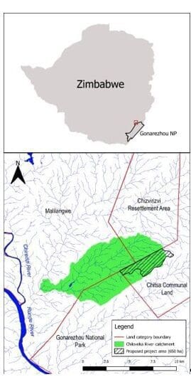
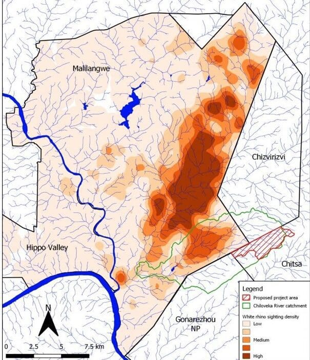
The project is confined to the fields (650 ha) of the Chitsa Communal land that lie within the boundaries of the Chiloveka River catchment (Figure 2). Approximately 2500 people rely on crops grown in these fields. Slopes are gentle but the vertic clay soils swell when wet, sealing the surface against further infiltration. This leads to large volumes of erosive runoff. Consequently, extensive networks of actively eroding rills and gullies are common. Chief Tshovani and Headman Chitsa are the traditional leaders of the villages that fall within the study area. They are supportive of the project and have given their consent. Additionally the local MP for the area has given his support. A presentation describing the project was made to the Chiredzi Rural District Council in 2021. The farmers whose fields lie within the study area are aware of the erosion problem and agreed to plant vetiver hedges to prevent further damage.
Erosion Control Strategy
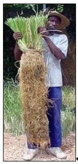
The vetiver system for controlling the erosion consists of numerous vegetative barriers comprising upright, rigid, dense, and deeply rooted tillers of vetiver clump grass that slows runoff and holds sediment on site. Over time, sediment accumulates on the upslope side of the hedge, eventually forming a natural terrace. Vetiver’s deep and massive root system can reach down two to three meters in the first year after planting (Figure 3). The measured maximum resistance of vetiver roots in soils is equivalent to one-sixth that of mild steel, and the root system has been shown to increase soil shear strength by as much as 39 %. Hedges are propagated and established vegetatively, and recommended cultivars are sterile and non-invasive.
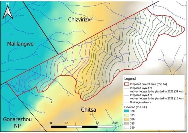
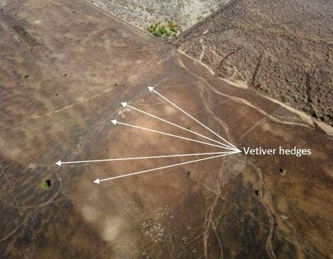
To control runoff and stabilize soil erosion, vetiver hedges are being planted along predefined contours located at 1 m height intervals. Following these https://getzonedup.com/limitless-pill/ recommendations, 38 hedge rows totalling 50 km are required to stabilize erosion within the project area (Figure 4).
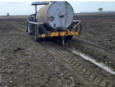
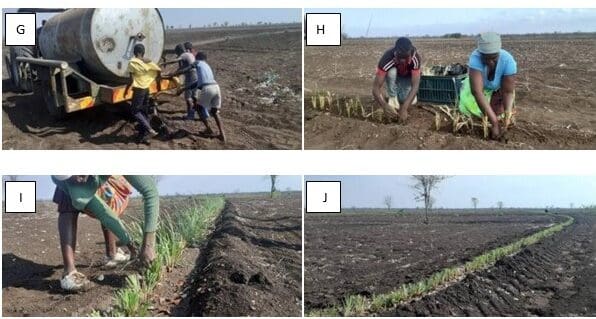
The high clay content of the soils within the project area dictates that planting takes place outside of the rainy season (May to November) as land preparation is impossible when the soil is wet. Additionally the rainy period is when farmers are planting their crops and access to their fields would be difficult. Planting the 50 km of hedge will be carried out over a 12 month period spanning two years – May 2021 to end October 2021 and June 2022 to November 2022. Because planting is done out of the rainy season the vetiver requires irrigation to establish. This is achieved using 5,000 ltr tractor drawn bowsers (Figure.5)
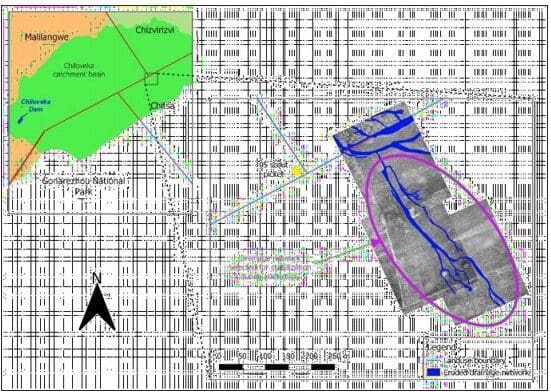
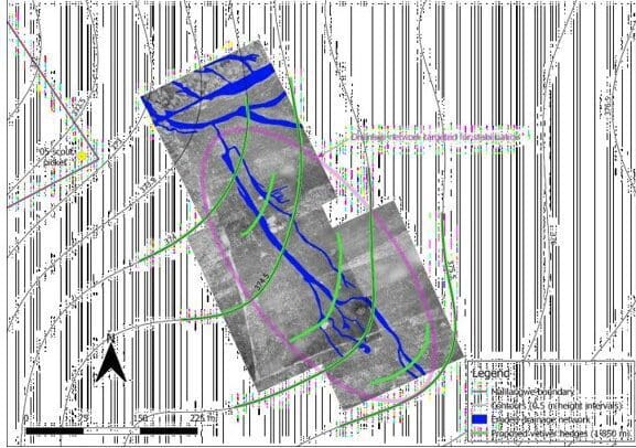
To derive a best practice protocol for hedge establishment, a pilot study to assess site-specific practicalities and costs was conducted in September and November 2020. The pilot study involved the planting of 1,850 m of vetiver hedge across an eroding drainage network in the north-western region of the project area (Figures 6, 7, & 8). Vetiver slips were planted out along the contours at a spacing of 10cm between slips. Where the hedge lines intersected large rills or gullies a double row was planted to provide extra support.
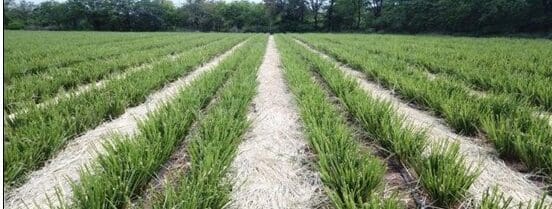
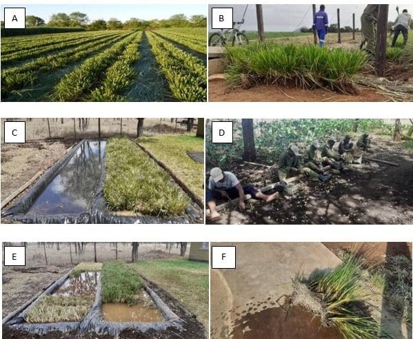
For the pilot study, vetiver crowns were purchased from Igoda Farm near Chiredzi. (Figure.9) Crowns were transported to the pilot study site by truck. This worked well and a similar procedure except using a tractor and trailer is used for the wider project.
The different stages of the planting process(harvesting crowns; splitting slips from crowns; preparation of planting furrows; planting slips into furrows; and irrigation (Figure 10) were completed with little trouble – these same procedures are being implemented for the wider project.
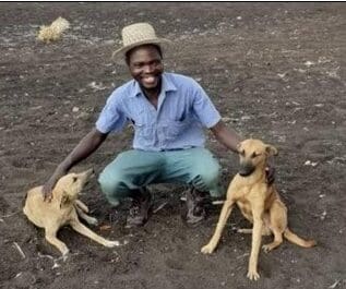
Plant mortality due to excessive herbivory of newly planted slips was a concern. The community largely solved this problem by using dogs they trained to chase cattle and goats away from the hedge rows (Figure 11) This is the primary mode of protection they use to protect their own crops of Maize and sorghum against cattle and goats, fencing being far too expensive an option. The owners of the dogs are employed by the project and benefit greatly from the income. At the peak of “demand” eight guards are employed using between 16 and 20 dogs.
The soils of the project area are fertile, and when adequately watered vetiver grows very well. Tractor drawn bowsers are used to irrigate hedges once daily for the first two or three weeks depending on temperatures, then once every second or third day during weeks four and five, thereafter the hedge lines are well enough established to receive only periodic irrigation until the onset of the rains towards the end of November or beginning of December. An existing borehole where Malilangwe, Chitsa and Chizvarizvi areas meet is being used when operating in the western half of the project area. A new borehole was drilled that caters for the eastern half. Borehole pumps have been coupled to diesel Lister engines as there is no power in the area. These will be replaced with solar pumps when the project is completed and handed over to the local community.
Newly established hedges in 2021 were tested by a first rain of 44 mm that produced significant runoff. Performance was excellent; with large
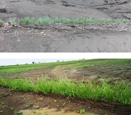
amounts of sediment being trapped and deposited on the upslope side of the hedges (Figures 12 & 13) By the end of the rains in
2021 some of these hedge lines recorded sediment retention depth of up to 23 cm across a number of gullies. The average depth of sediment retained over much of last year’s planting was 12cm. This was measured at areas where hedges intersected larger gullies and does not include sediment that was retained along the many thousands of smaller rills.
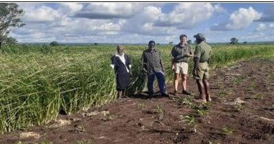
The 25000m (25km) of vetiver hedge planted in 2021 have been divided into sections that are individually owned by farmers. Each farmer owning the section of hedge that runs through his or her plot. This is a very important development as it indicates that the farmers place sufficient value on the hedges to warrant ownership, which ensures that the hedges will be properly maintained in the future. In addition to curbing erosion, the hedges also provide a significant source of forage for domestic stock – a resource that is in very short supply in the area, particularly during the hot-dry season. An established hedge cut four possibly six times per year can produce around 7 kg of forage per meter per year. This can potentially provide much needed forage for community livestock. The hedges have already been cut several times and the forage fed to livestock.
At Chitsa, as with many other communities, the greatest factor limiting crop production is plant available moisture. Water retention levels are currently low in the fields because a large proportion of rain inputs are lost as runoff. Vetiver will improve this because the hedges will slow overland flow, which will promote infiltration and increase soil water storage in the crop rooting zone. This will translate into higher yields and improved food security.
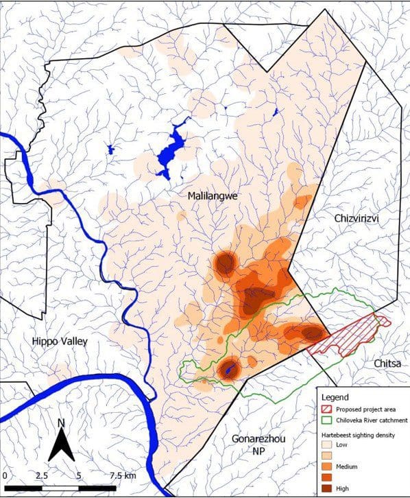
If runoff from the fields is controlled, downstream impacts in Malilangwe Wildlife Reserve will be reduced. Because of their lower topographical position and higher soil clay content, the shallow u-shaped valleys of the Chiloveka drainage system have elevated levels of soil moisture relative to the surrounding terrain. This has resulted in the development of hydromorphic grasslands (dambos) within the drainage lines that are an important source of green grass during the hot-dry season for white rhinoceros and Lichtenstein’s hartebeest (Figures 14 & 15). Unfortunately, flood waters from the Chitsa fields have damaged several of these grasslands, and the forage they supplied has been lost. It is critically important that further damage be avoided because both white rhinoceros and Lichtenstein’s hartebeest are endangered in Zimbabwe. This is particularly true for the hartebeest because Malilangwe is home to one of the last remaining free- ranging populations in Zimbabwe (estimated at 60 animals), and the hydromorphic grasslands of the Chiloveka drainage system are central to this population’s survival.
Costs
Costs for the 2021 phase are significantly higher than 2022 due to the purchase of capital items which include 2 x 4 wheel drive 80 hp tractors, 2 x motorcycles, 3 x 5000ltr bowsers, 1 x 500 ltr diesel bowser, 1 x 5.5 hp diesel lister engine, 2 x submersible pumps, 1 x solar pump kit system. Capital expenditure comprised the largest proportion of cost, followed by management, labour and operational expenses, respectively. Capex cost for 2021 totalled $167,086.00 and operational costs amounted to $83,380.69.
Operational costs for 2022 are predicted to be similar to 2021 despite increases. This is due to more efficient methods of planting, stricter procedures and more effective water storage and pumping systems. This has translated to faster turn-around times for the tractors and bowsers in turn leading to quicker establishment of vetiver lines. Transport of crowns to the project site is better organised and able to keep ahead of the rate of planting. Ponds never run out of planting material as was frequently the case in 2021. All this means more kilometres planted monthly at the same cost. Additionally the communities employed in the project have a better understanding of what is required having worked on the project the previous year. Daily tasks such as digging furrows and planting are carried out quicker allowing more lines to be completed per month.
By the end of October it is anticipated that the whole project should effectively be
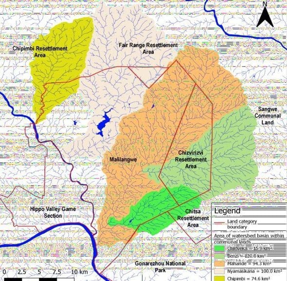
completed at a cost of around $357,000 or put another way $7.15 per meter. (Inclusive of Capex). This may be considered expensive by some but if the Capital costs were excluded these costs are not unreasonable. It is the intention to use the equipment to stabilise other catchments in the area (Figure 16). By repurposing the equipment in this way, the capital costs of this project will be spread over many similar projects, significantly reducing the cost of establishing vetiver hedge rows over similar distances.
Should further funding be sourced to cover operational costs, additional projects would be initiated within communities bordering the conservancies as these areas have been identified as high risk, both for the communities and conservancies? Dealing first with these areas in such arid conditions and having proved the vetiver system works extremely well, will serve as an example to many other areas of Zimbabwe who could adopt similar strategies to avoid disaster.
This project is certainly the largest of its kind in Zimbabwe and a great deal of thanks must go to the Malilangwe Trust for the initial funding. Now that the capital Items have been procured and can be repurposed to other similar projects, it now remains for us to source operational funding to continue with other areas in dire need of erosion intervention.
Cost-Benefit Analysis
Is it possible to put a price on soil? Soil is replaced when rock weathers over geological time, which is measured in hundreds of thousands of years. This means that for human purposes soil cannot be replaced. If lost, it is gone forever. This, coupled with humanities’ absolute dependence on soil for survival, renders it a priceless natural asset. We simply cannot afford to lose soil and should do everything in our power to conserve it. That being said, soil’s apparent abundance dampens the sense of urgency that should surround its conservation. All too often, full realisation of the problem happens too late – once the erosion juggernaut has already gained momentum and the problem has become very difficult or impossible to solve. It is our intention not to allow this to happen at Chitsa. In the short-term, approximately 2500 people are dependent on soil in the project area for their food requirements. This number is far greater if the consequence of doing nothing is projected over the long-term. It is our hope that Chita’s agricultural potential be preserved for the next hundred years and beyond. If this project acts as the catalyst for a sustainable culture of soil conservation in the area, then its cost must be considered a small price for such an achievement.
With projects of this nature, lasting positive impact is best achieved by changing the mindsets of the people involved. Vetiver appears to have real potential in this regard. The hedges generate a feeling of order and sophistication to what is otherwise a rather rudimentary agricultural system. Observations over the course of the pilot study in 2021 suggest that the vetiver hedges may have generated a new sense of pride and conscientiousness in the owners of the fields involved. This may in turn lead to a culture of soil conservation that could spread to neighbouring farming communities once the benefits become apparent.
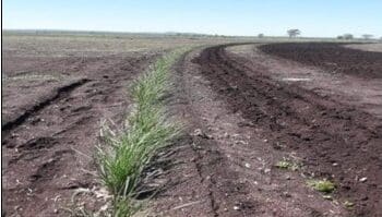
Farmers whose fields were involved in the pilot study are now ploughing along the contour, using the hedge line as a guide (Figure 17.) whereas previously they were ploughing with the slope, exacerbating the erosion problem in the process.
Conclusion
The erosion control strategy described in this article has been parameterised according to the site-specific findings of a detailed pilot study in 2020 and subsequently the roll out of the wider project over 2021 continuing into 2022. Crops cannot be grown without soil and therefore it follows that soil conservation underpins food security. Consequently, the importance of interventions that protect this priceless natural asset cannot be overstated. The costs of the project may be seen as high by some, but when considered that the capital expenditure will be spread across several similar projects, the expense is easily justified.
